Google Earth Engine
What is Earth Engine?
Earth Engine is a platform for scientific analysis and visualization of geospatial datasets, for academic, non-profit, business and government users.
Earth Engine hosts satellite imagery and stores it in a public data archive that includes historical earth images going back more than forty years. The images, ingested on a daily basis, are then made available for global-scale data mining.
Earth Engine also provides APIs and other tools to enable the analysis of large datasets.
How do I get access?
To get access to Earth Engine, please fill out the form at signup.earthengine.google.com. You will receive an email titled “Welcome to Google Earth Engine” with instructions for getting started.
What datasets are available?
We have a searchable data catalog, including the entire EROS (USGS/NASA) Landsat catalog, numerous MODIS datasets, Sentinel-1 data, NAIP data, precipitation data, sea surface temperature data, CHIRPS climate data, and elevation data.
Users can also upload their own data for analysis in Earth Engine, with full control over access.
Can I use my own proprietary imagery and vector data?
Yes. Earth Engine enables you to upload your own raster and vector data (e.g. GeoTIFF or Shape files) for analysis.
You can use the Asset Manager to upload datasets in the Shapefile or CSV format or to upload image or other georeferenced raster datasets in GeoTIFF or TFRecord format.
Note
Your uploaded assets are initially private, but can be shared as described in the Sharing Assets Section.
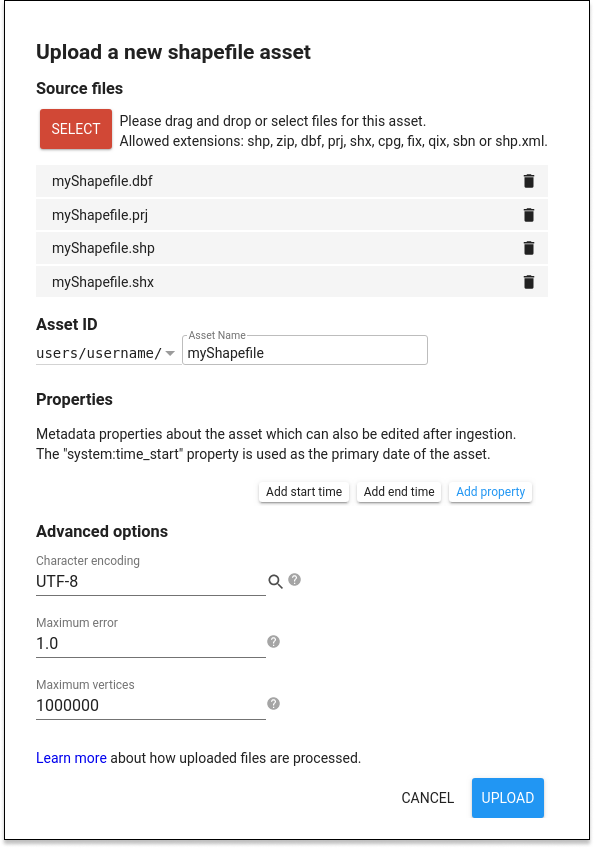
Uploading table assets (shapefile, csv)
To upload a Shapefile from the Code Editor, click the  button, then select Shape files under the Table Upload section. An upload dialog similar to Figure 1 will be presented. Click the SELECT button and navigate to a Shapefile or Zip archive containing a Shapefile on your local file system. When selecting a .shp file, be sure to select the related .dbf, .shx and .prj files. Earth Engine will default to WGS84 (longitude, latitude) coordinates if a .prj file is not provided. If you are uploading a Zip archive, make sure it contains only one Shapefile (set of .shp, .dbf, .shx, .prj, etc.) and no duplicate filenames. Make sure filenames do not include additional periods or dots. (Filenames will include a single period before
the extension.)
button, then select Shape files under the Table Upload section. An upload dialog similar to Figure 1 will be presented. Click the SELECT button and navigate to a Shapefile or Zip archive containing a Shapefile on your local file system. When selecting a .shp file, be sure to select the related .dbf, .shx and .prj files. Earth Engine will default to WGS84 (longitude, latitude) coordinates if a .prj file is not provided. If you are uploading a Zip archive, make sure it contains only one Shapefile (set of .shp, .dbf, .shx, .prj, etc.) and no duplicate filenames. Make sure filenames do not include additional periods or dots. (Filenames will include a single period before
the extension.)
Give the table an appropriate asset ID (which doesn’t already exist) in your user folder. Click UPLOAD to start the upload.
var roi = ee.FeatureCollection("users/nicolasdeffense/extent_roi_32631")
Datasets present in Google Earth engine
You can also use the datasets present in Google Earth engine. For instance, the FAO Global Administrative Unit Layers (GAUL) compiles and disseminates the best available information on administrative units for all the countries in the world, providing a contribution to the standardization of the spatial dataset representing administrative units. Check this website to easily find the code of the country/region you want to work on.
// Import Belgium boundary
var fao_level0 = ee.FeatureCollection("FAO/GAUL/2015/level0")
var belgium = fao_level0.filter("ADM0_NAME == 'Belgium'")

// Import Walloon Region boundary
var fao_level1 = ee.FeatureCollection("FAO/GAUL/2015/level1")
var wallonia = fao_level1.filter("ADM1_CODE == 602")
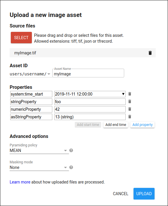
Uploading image assets (GeoTIFF)
To upload a GeoTIFF using the Code Editor, select the Assets tab in the upper left corner, click the button, then select Image upload. Earth Engine presents an upload dialog which should look similar to Figure 1. Click the SELECT button and navigate to a GeoTIFF on your local file system.
Give the image an appropriate asset ID (which doesn’t already exist) in your user folder. If you’d like to upload the image into an existing folder or collection, prefix the asset ID with the folder or collection ID, for example /users/name/folder-or-collection-id/new-asset.
Click UPLOAD to start the upload.