Processing Levels
Level-1C
Level-1C product provides orthorectified Top-Of-Atmosphere (TOA) reflectance, with sub-pixel multispectral registration. Cloud and land/water masks are included in the product.
Level-2A
Level-2A product provides orthorectified Bottom-Of-Atmosphere (BOA) reflectance, with sub-pixel multispectral registration. A Scene Classification map (cloud, cloud shadows, vegetation, soils/deserts, water, snow, etc.) is included in the product.
The Level-2A operational processor (Sen2Cor) generates Level-2A (BOA reflectance) products from Level-1C products. This processing is split into two parts:
Scene Classification (SC) algorithm aims at providing a pixel classification map
Atmospheric Correction (S2AC) aims at transforming TOA reflectance into BOA reflectance.
From the mid-March 2018, the Level-2A became an operational product, beginning with coverage of the Euro-Mediterranean region. Global coverage started in December 2018.
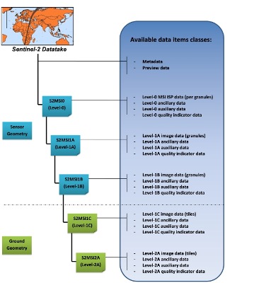
Sentinel-2 processing levels. Only Level-1C and Level-2A products (in green) are made available to users
Level-1C and Level-2A are projected onto a UTM/WGS84 grid and made available publicly on 100x100 km tiles. Each tile has a unique ID. Take a look on the Sentinel-2 UTM tiling grid by clicking here !

Sentinel-2 tiles in Belgium. Three tiles cover the majority of the Belgian territory: 31UES, 31UFS and 31UFR
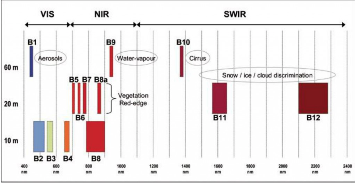
Spectral bands & spatial resolution
The spatial resolution of Sentinel-2 is dependent on the particular spectral band.
10m spatial resolution |
20m spatial resolution |
60m spatial resolution |
|---|---|---|
B2 (490 nm) |
B5 (705 nm) |
B1 (443 nm) |
B3 (560 nm) |
B6 (740 nm) |
B9 (940 nm) |
B4 (665 nm) |
B7 (783 nm) |
B10 (1375 nm) |
B8 (842 nm) |
B8a (865 nm) |
|
B11 (1610 nm) |
||
B12 (2190 nm) |
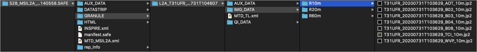
Data Formats
Sentinel-2 products are made available to users in SENTINEL-SAFE format, including image data in JPEG2000 format, quality indicators (e.g. defective pixels mask), auxiliary data and metadata.
The SAFE format has been designed to act as a common format for archiving and conveying data within ESA Earth Observation archiving facilities. The SAFE format wraps a folder containing image data in a binary data format and product metadata in XML. This flexibility allows the format to be scalable enough to represent all levels of SENTINEL products.
A Sentinel-2 product refers to a directory folder that contains a collection of information. It includes:
a manifest.safe file which holds the general product information in XML
a preview image in JPEG2000 format
subfolders for measurement datasets including image data (granules/tiles) in GML-JPEG2000 format
subfolders for datastrip level information
a subfolder with auxiliary data (e.g. International Earth Rotation & Reference Systems (IERS) bulletin)
HTML previews
The Level-2A prototype product is an orthorectified product providing Bottom-Of-Atmosphere (BOA) reflectances, and basic pixel classification (including classes for different types of cloud).
The Level-2A image data product uses the same tiling, encoding and filing structure as Level-1C.
The Level-2 product is also in SAFE format, which groups together several types of file:
metadata file (XML file)
preview image (JPEG2000 with GML geo-location)
tiles files with BOA reflectances image data file (GML / JPEG2000) for each tile
datastrip files
auxiliary data
ancillary data (Ground Image Processing Parameters (GIPPs))
Note
Before starting this notebook, you should download Sentinel-2 Level-2A products. The L2A products are downloadable by tiles which are 100x100 km ortho-images in UTM/WGS84 projection.