In situ split calibration-validation with complex strategies (optional)
[2]:
import pandas as pd
import geopandas as gpd
import matplotlib.pyplot as plt
import matplotlib.patches as mpatches
import numpy as np
import plotly.express as px
from collections import defaultdict
from pathlib import Path
Set directory
[3]:
computer_path = '/export/miro/ndeffense/LBRAT2104/'
grp_nb        = '99'

# Directory for all work files
work_path = f'{computer_path}STUDENTS/GROUP_{grp_nb}/TP/'

in_situ_prepro_path  = f'{work_path}B_IN_SITU_PREPRO/'
in_situ_cal_val_path = f'{work_path}C_IN_SITU_CAL_VAL/'

Path(in_situ_cal_val_path).mkdir(parents=True, exist_ok=True)
Set parameters
[4]:
site = 'NAMUR'
year = '2020'

field_classif_code = 'grp_1_nb'
field_classif_name = 'grp_1'

pix_best = 10
pix_ratio_threshold = 0.05

sample_ratio_hi = 0.25
sample_ratio_lo = 0.75
Set filenames
[5]:
# Input file
in_situ_prepared_shp = f'{in_situ_prepro_path}{site}_{year}_IN_SITU_ROI_prepared.shp'

# Output files
in_situ_cal_shp = f'{in_situ_cal_val_path}{site}_{year}_IN_SITU_ROI_CAL.shp'
in_situ_val_shp = f'{in_situ_cal_val_path}{site}_{year}_IN_SITU_ROI_VAL.shp'
1. Open in situ data prepared
[6]:
gdf = gpd.read_file(in_situ_prepared_shp)

display(gdf.head())
| id | lc_nb | lc | grp_nb | grp | class_nb | class | sub_nb | sub | grp_1_nb | grp_1 | grp_A_nb | grp_A | area | pix_count | geometry | |
|---|---|---|---|---|---|---|---|---|---|---|---|---|---|---|---|---|
| 0 | 4 | 3 | Grassland and meadows | 31 | Grassland and meadows | 319 | Grassland and meadows | 3199 | Grassland and meadows | 3 | Grassland and meadows | 3 | Grassland and meadows | 1735 | 17 | MULTIPOLYGON (((630003.573 5594258.004, 630003... |
| 1 | 5 | 3 | Grassland and meadows | 31 | Grassland and meadows | 319 | Grassland and meadows | 3199 | Grassland and meadows | 3 | Grassland and meadows | 3 | Grassland and meadows | 14331 | 146 | POLYGON ((636962.589 5595674.757, 636966.536 5... |
| 2 | 6 | 3 | Grassland and meadows | 31 | Grassland and meadows | 319 | Grassland and meadows | 3199 | Grassland and meadows | 3 | Grassland and meadows | 3 | Grassland and meadows | 1768 | 18 | POLYGON ((635692.119 5593303.601, 635688.405 5... |
| 3 | 7 | 3 | Grassland and meadows | 31 | Grassland and meadows | 319 | Grassland and meadows | 3199 | Grassland and meadows | 3 | Grassland and meadows | 3 | Grassland and meadows | 7828 | 79 | POLYGON ((627911.368 5595749.375, 627942.033 5... |
| 4 | 9 | 3 | Grassland and meadows | 31 | Grassland and meadows | 319 | Grassland and meadows | 3199 | Grassland and meadows | 3 | Grassland and meadows | 3 | Grassland and meadows | 3197 | 39 | POLYGON ((633236.525 5596165.100, 633397.286 5... |
2. Get “pixel ratio” for each polygons
Pixel ratio = number of 10m pixels belonging to specific crop type divided by the total number of 10m pixels
$ pix_ratio = \frac{crop\_pix}{total\_pix} $
All polygons from a same class will have the same pixel ratio !
[7]:
gdf['crop_pix'] = gdf.groupby(field_classif_code)['pix_count'].transform('sum')

gdf['pix_ratio'] = gdf['crop_pix'] / gdf['pix_count'].sum()

display(gdf.head())
| id | lc_nb | lc | grp_nb | grp | class_nb | class | sub_nb | sub | grp_1_nb | grp_1 | grp_A_nb | grp_A | area | pix_count | geometry | crop_pix | pix_ratio | |
|---|---|---|---|---|---|---|---|---|---|---|---|---|---|---|---|---|---|---|
| 0 | 4 | 3 | Grassland and meadows | 31 | Grassland and meadows | 319 | Grassland and meadows | 3199 | Grassland and meadows | 3 | Grassland and meadows | 3 | Grassland and meadows | 1735 | 17 | MULTIPOLYGON (((630003.573 5594258.004, 630003... | 23889 | 0.222207 |
| 1 | 5 | 3 | Grassland and meadows | 31 | Grassland and meadows | 319 | Grassland and meadows | 3199 | Grassland and meadows | 3 | Grassland and meadows | 3 | Grassland and meadows | 14331 | 146 | POLYGON ((636962.589 5595674.757, 636966.536 5... | 23889 | 0.222207 |
| 2 | 6 | 3 | Grassland and meadows | 31 | Grassland and meadows | 319 | Grassland and meadows | 3199 | Grassland and meadows | 3 | Grassland and meadows | 3 | Grassland and meadows | 1768 | 18 | POLYGON ((635692.119 5593303.601, 635688.405 5... | 23889 | 0.222207 |
| 3 | 7 | 3 | Grassland and meadows | 31 | Grassland and meadows | 319 | Grassland and meadows | 3199 | Grassland and meadows | 3 | Grassland and meadows | 3 | Grassland and meadows | 7828 | 79 | POLYGON ((627911.368 5595749.375, 627942.033 5... | 23889 | 0.222207 |
| 4 | 9 | 3 | Grassland and meadows | 31 | Grassland and meadows | 319 | Grassland and meadows | 3199 | Grassland and meadows | 3 | Grassland and meadows | 3 | Grassland and meadows | 3197 | 39 | POLYGON ((633236.525 5596165.100, 633397.286 5... | 23889 | 0.222207 |
3. Assign sampling design strategy for each polygons
the smallest polygons are automatically NOT considered for the calibration and thus assigned to the validation pool;
for each class, the number of training pixels \(crop\_target\) is defined considering the size of the class;
calibration polygons are randomly selected to reach this \(crop\_target\) value and the remaining polygons are allocated to the validation.
Strategy 1 — majority classes
By default, the majority classes are defined as those counting a number of 10m pixels corresponding to more than 5% (pix_ratio_threshold) of the total number of pixels considering all classes to map.
Crop type belongs to strategy 1 if :
\(pix\_ratio ≥ pix\_ratio\_threshold\)
In this case, for each majority class, the number of training pixels \(crop\_target\) will correspond to 25% of the number of pixels of the class (crop_pixels) :
\(crop\_target = sample\_ratio\_hi \times crop\_pix\)
Strategy 2 — minority classes
The minor classes are defined as those counting a number of S2 pixels corresponding to less than 5% of the total number of pixels considering all classes to map.
Crop type belongs to strategy 2 if :
\(pix\_ratio < pix\_ratio\_threshold\)
In this case, for each minor class, the number of training pixels \(crop\_target\) will correspond to 75% of the number of pixels of the class :
\(crop\_target = sample\_ratio\_lo \times crop\_pix\)
[9]:
# Assign sampling design strategy for each polygons
# -------------------------------------------------

gdf['strategy'] = np.where(gdf['pix_count'] < pix_best, 3,
                           np.where(gdf['pix_ratio'] >= pix_ratio_threshold, 1, 2))


# Build a table to summarize the strategy assign to each class
df = gdf[[field_classif_code,field_classif_name,'crop_pix','pix_ratio','strategy']].drop_duplicates()
df = df[df['strategy'] != 3].sort_values('pix_ratio', ascending=False)

display(df)


# Split polygons in training and validation datasets
# --------------------------------------------------

training_pixels = defaultdict(lambda: 0)
training_target = {}

cal_id_list = []
val_id_list = []

gdf_shuffle = gdf.sample(len(gdf), random_state=1)  # Shuffle geodataframe randomly

for i, row in gdf_shuffle.iterrows():

    id          = row['id']
    crop_code   = row[field_classif_code]
    crop_pix    = row['crop_pix']
    strategy    = row['strategy']
    pix_count   = row['pix_count']

    if strategy != 3:
        if strategy == 1:
            crop_target = sample_ratio_hi * crop_pix
            training_target[crop_code] = crop_target

        elif strategy == 2:
            crop_target = sample_ratio_lo * crop_pix
            training_target[crop_code] = crop_target

        pixels = training_pixels[crop_code]

        if pixels + pix_count <= crop_target:  # If below crop target, add polygons in training set
            training_pixels[crop_code] = pixels + pix_count  # Update number of training pixels by crop code
            purpose = 0  # training

        else:
            purpose = 1  # validation because "crop target" is reached
    else:
        purpose = 1  # validation because polygons do not contain enough pixels (= strategy 3)

    if purpose == 0:
        cal_id_list.append(id)
    else:
        val_id_list.append(id)


print(f'Number of polygons for training   : {len(cal_id_list)}')
print(f'Number of polygons for validation : {len(val_id_list)}')

cal_gdf = gdf[gdf['id'].isin(cal_id_list)]

val_gdf = gdf[gdf['id'].isin(val_id_list)]
| grp_1_nb | grp_1 | crop_pix | pix_ratio | strategy | |
|---|---|---|---|---|---|
| 221 | 1111 | Winter wheat | 29633 | 0.275635 | 1 |
| 0 | 3 | Grassland and meadows | 23889 | 0.222207 | 1 |
| 295 | 1121 | Maize | 8667 | 0.080617 | 1 |
| 331 | 1811 | Sugar beet | 7400 | 0.068832 | 1 |
| 352 | 1152 | Barley six-row | 6659 | 0.061940 | 1 |
| 441 | 1511 | Potatoes | 6439 | 0.059893 | 1 |
| 376 | 1192 | Other cereals | 6117 | 0.056898 | 1 |
| 411 | 1771 | Peas | 3606 | 0.033542 | 2 |
| 502 | 69 | Forest | 3109 | 0.028919 | 2 |
| 403 | 1923 | Flax hemp and other similar crops | 2810 | 0.026138 | 2 |
| 455 | 21 | Fruits trees | 2239 | 0.020826 | 2 |
| 421 | 1435 | Rapeseed | 1826 | 0.016985 | 2 |
| 466 | 81 | Urban | 1795 | 0.016696 | 2 |
| 409 | 121 | Leafy or stem vegetables | 1351 | 0.012567 | 2 |
| 394 | 1171 | Oats | 776 | 0.007218 | 2 |
| 434 | 1911 | Alfalfa | 554 | 0.005153 | 2 |
| 429 | 84 | Greenhouses | 252 | 0.002344 | 2 |
| 462 | 9212 | Permanent rivers and streams | 208 | 0.001935 | 2 |
| 372 | 22 | Vineyards | 178 | 0.001656 | 2 |
Number of polygons for training   : 205
Number of polygons for validation : 332
Get summary of the CAL/VAL splitting
[10]:
# Get number of pixels per class

pix_per_class_cal_df = cal_gdf.groupby([field_classif_code, field_classif_name])['pix_count'].agg('sum').to_frame().reset_index()
pix_per_class_cal_df = pix_per_class_cal_df.sort_values(by='pix_count', ascending=False)
pix_per_class_cal_df = pix_per_class_cal_df.rename(columns={"pix_count": "CAL_pix"})

pix_per_class_val_df = val_gdf.groupby([field_classif_code, field_classif_name])['pix_count'].agg('sum').to_frame().reset_index()
pix_per_class_val_df = pix_per_class_val_df.sort_values(by='pix_count', ascending=False)
pix_per_class_val_df = pix_per_class_val_df.rename(columns={"pix_count": "VAL_pix"})

# Get number of polygons per class

poly_per_class_cal_df = cal_gdf.groupby([field_classif_code, field_classif_name])[field_classif_code].agg('count').reset_index(name='poly_count')
poly_per_class_cal_df = poly_per_class_cal_df.sort_values(by='poly_count', ascending=False)
poly_per_class_cal_df = poly_per_class_cal_df.rename(columns={"poly_count": "CAL_poly"})

poly_per_class_val_df = val_gdf.groupby([field_classif_code, field_classif_name])[field_classif_code].agg('count').reset_index(name='poly_count')
poly_per_class_val_df = poly_per_class_val_df.sort_values(by='poly_count', ascending=False)
poly_per_class_val_df = poly_per_class_val_df.rename(columns={"poly_count": "VAL_poly"})


# Merge 2 previous dataframe in a single one
#pix_poly_per_class_df = pix_per_class_cal_df.merge(poly_per_class_df, on=[field_classif_code, field_classif_name], how="outer")


# Merge 4 previous dataframe in a single one
summary_df = pix_per_class_cal_df.merge(pix_per_class_val_df,on=[field_classif_code, field_classif_name]).merge(poly_per_class_cal_df,on=[field_classif_code, field_classif_name]).merge(poly_per_class_val_df,on=[field_classif_code, field_classif_name])

display(summary_df)
| grp_1_nb | grp_1 | CAL_pix | VAL_pix | CAL_poly | VAL_poly | |
|---|---|---|---|---|---|---|
| 0 | 1111 | Winter wheat | 7403 | 22230 | 15 | 59 |
| 1 | 3 | Grassland and meadows | 5971 | 17918 | 60 | 161 |
| 2 | 1771 | Peas | 2454 | 1152 | 8 | 2 |
| 3 | 69 | Forest | 2296 | 813 | 28 | 7 |
| 4 | 1121 | Maize | 2132 | 6535 | 10 | 26 |
| 5 | 1923 | Flax hemp and other similar crops | 2059 | 751 | 5 | 3 |
| 6 | 1811 | Sugar beet | 1850 | 5550 | 4 | 17 |
| 7 | 1152 | Barley six-row | 1663 | 4996 | 8 | 12 |
| 8 | 1511 | Potatoes | 1577 | 4862 | 4 | 10 |
| 9 | 21 | Fruits trees | 1551 | 688 | 6 | 1 |
| 10 | 1192 | Other cereals | 1477 | 4640 | 7 | 10 |
| 11 | 81 | Urban | 1338 | 457 | 27 | 9 |
| 12 | 1435 | Rapeseed | 1176 | 650 | 4 | 2 |
| 13 | 121 | Leafy or stem vegetables | 566 | 785 | 2 | 2 |
| 14 | 1171 | Oats | 534 | 242 | 5 | 3 |
| 15 | 1911 | Alfalfa | 403 | 151 | 4 | 3 |
| 16 | 84 | Greenhouses | 183 | 69 | 3 | 2 |
| 17 | 9212 | Permanent rivers and streams | 152 | 56 | 3 | 1 |
| 18 | 22 | Vineyards | 124 | 54 | 2 | 2 |
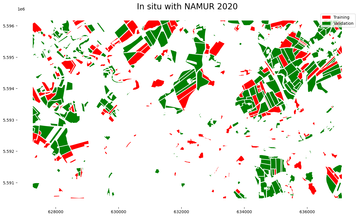
Plot calibration and validation in situ data
[11]:
fig, ax = plt.subplots(1, 1, figsize=(15,15))

cal_gdf.plot(ax=ax,
            color='red')

val_gdf.plot(ax=ax,
            color='green')

ax.set_title(f'In situ with {site} {year}',fontsize=20)

cal_patch = mpatches.Patch(color='red', label='Training')
val_patch = mpatches.Patch(color='green', label='Validation')


plt.legend(handles=[cal_patch, val_patch])

plt.box(False)
Write geodataframe into a shapefile
[13]:
cal_gdf.to_file(in_situ_cal_shp)
val_gdf.to_file(in_situ_val_shp)

print(f'Two shapefiles have been created :\n {in_situ_cal_shp} \n {in_situ_val_shp}')
Two shapefiles have been created :
 /export/miro/ndeffense/LBRAT2104/STUDENTS/GROUP_99/TP/C_IN_SITU_CAL_VAL/NAMUR_2020_IN_SITU_ROI_CAL.shp
 /export/miro/ndeffense/LBRAT2104/STUDENTS/GROUP_99/TP/C_IN_SITU_CAL_VAL/NAMUR_2020_IN_SITU_ROI_VAL.shp